Berkeley
- Pushing the limits of today's techniques for monitoring
earthquake fault activity, a geophysicist at the University
of California, Berkeley, assessed movement along the northern
Hayward fault and found less chance of a major quake originating
on that segment than previously thought.
 With
the help of radar interferometry and data from global positioning
satellites (GPS), plus analysis of repeating microquakes 6
miles below the surface, he and his colleagues concluded that
the deep portions of the fault steadily slip at about the
same rate as the surface does. This means the rocks deep below
the surface aren't locked and building up strain that could
be released in a catastrophic quake.
With
the help of radar interferometry and data from global positioning
satellites (GPS), plus analysis of repeating microquakes 6
miles below the surface, he and his colleagues concluded that
the deep portions of the fault steadily slip at about the
same rate as the surface does. This means the rocks deep below
the surface aren't locked and building up strain that could
be released in a catastrophic quake.
"Our research
shows no evidence of locking at any depth, which means the
threat from one of our worst hazards, right in our backyard,
is much reduced," said Roland Bürgmann, assistant professor
of geology and geophysics at UC Berkeley. "However, other
hazards - from the southern Hayward fault, the San Andreas
fault and other nearby faults - leave the need to build reinforced
homes and the need to be prepared just as high as before."
Bürgmann
and his colleagues at UC Berkeley, the Lawrence Berkeley National
Laboratory, the Jet Propulsion Laboratory in Pasadena, Calif.,
and UC Davis report their findings in the Aug. 18 issue of
Science magazine.
The Hayward
fault, considered one of the most dangerous faults in California,
stretches more than 60 miles from San Pablo Bay in the north
to below Fremont in the south, and is a branch of the more
famous San Andreas fault that extends much of the length of
California. Last year a state-wide team of seismologists estimated
a 32 percent chance of a major quake originating somewhere
on the Hayward fault in the next 30 years. A major quake is
one of magnitude 6.7 or greater.
The segment
of the Hayward fault from San Pablo Bay south to the border
between Berkeley and Oakland is referred to as the northern
Hayward fault, which may connect under the bay with the Rogers
Creek fault that runs through Napa County. Until recently,
the northern Hayward fault also was ranked high in terms of
the chance of a major quake. The latest assessment, that of
the U.S. Geological Survey Working Group on California Earthquake
Probabilities issued last October, lowered this risk, in part
based on preliminary findings supplied by Bürgmann's
team.
Bürgmann
set out several years ago to clarify the confusing history
of earthquake activity along the northern Hayward fault. If,
as trenching evidence suggests, the northern segment was the
site of a major quake sometime between the mid-1600s and the
arrival of Spanish colonists in 1776, why hasn't another quake
occurred since then, Bürgmann wondered. Perhaps, he thought,
the fault slips freely and large quakes do not occur on the
northern segment.
"We know
the Hayward fault creeps at about 5 millimeters per year at
the surface, but we don't know how deep this creep goes,"
Bürgmann said. "We decided to use all the data that exists
to try to say how deep the creep goes, and whether the fault
is locked at depth."
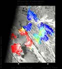
The techniques
Bürgmann used to study activity along the fault have
just recently become available. Only within the past few years
has interferometric synthetic aperture radar (InSAR) from
satellites been used to measure ground motion along faults.
Thanks to detailed mathematical analysis, it is possible to
determine the surface displacement that has occurred between
successive orbits of the satellite, even when the orbits are
years apart. With data taken in 1992 and 1997 by a pair of
European satellites, ERS-1 and ERS-2, plus analysis software
developed at JPL, Bürgmann was able to determine the
surface creep within a few millimeters along the northern
Hayward fault.
"The global
coverage of the European radar satellites allows the same
interferometry technique used in this study to be applied
to active faults in other parts of the world," said co-author
Eric Fielding, a JPL geophysicist. "There are few places in
the world that have the detailed ground information that was
available for this study, but radar satellites image nearly
everywhere. This allows us to study active faults in regions
such as Turkey, Iran and Tibet to learn more about how faults
behave. Because faults may behave differently at different
times, it is important to look at a wide variety of faults
to understand all of the possible types of behavior."
As a check
on these measurements, Bürgmann took advantage of regional
GPS stations that have been in place for nearly a decade.
Data from the GPS network supply only regional slip rates,
however. The GPS stations are not close enough to the northern
Hayward fault to give precise slip rates for that segment.
In addition,
seismologists at UC Berkeley and LBNL have just recently discovered
that repeating microquakes - quakes too small to be felt but
indicative of small patches of the fault suddenly slipping
deep underground - can reveal the amount of movement below
the surface. This technique was calibrated at a study site
on the San Andreas fault near Parkfield, 165 miles south of
San Francisco, by Robert Nadeau, a researcher in the Berkeley
Seismological Laboratory, and Thomas McEvilly, a professor
emeritus of geology at UC Berkeley. Both are members of the
Earth Sciences Division at LBNL.
"They found
that some of these microquakes were occurring at exactly the
same spot, and that the microquake clusters could be used
to infer how fast the fault is creeping near these stuck fault
patches deep underground," Bürgmann said. "We found clusters
of repeating microquakes as deep as 6 miles under Berkeley,
which is evidence of structural creep far below the surface."
Putting
all this information together, he estimated that the northern
Hayward fault slips underground at a rate of about 5 to 7
millimeters per year, essentially the same rate as at the
surface. The similar rates indicate that the fault is slipping
freely without locking, he said.
Over long
periods, and counting the slippage that occurs during and
after earthquakes, the entire Hayward fault moves on average
about 10 millimeters per year. The northern segment moves
less than this because it is pinned by the southern segment,
which is locked. In fact, though the entire fault moves at
about 10 millimeters per year, surface creep along the southern
segment is only 5 millimeters per year, which means strain
builds up that can only be released in an earthquake.
Most faults
outside California do not slip freely, but lock at depth.
Bürgmann said what may allow the northern Hayward fault -
and some other state faults - to move freely is a greenish
rock that underlies much of central and northern California
and could serve as a lubricant: serpentinite, often called
serpentine. Serpentinite, the official state rock, is soft
and fractures easily.
Bürgmann
hopes to continue his studies of the Hayward fault and other
faults that underlie the area.
"We can
use these same techniques to measure the strain built up in
the faults in surrounding regions, making the Bay Area a natural
laboratory for the study of earthquake faults," Bürgmann said.
Co-authors
of the paper with Bürgmann, Nadeau and McEvilly are Eric Fielding
of JPL, graduate student David Schmidt, M. D'Alessio and Mark
Murray, all of the Berkeley Seismological Laboratory, and
D. Manaker of UC Davis.
The work
was supported by the National Science Foundation, the Solid
Earth and Natural Hazards program of the National Aeronautics
and Space Administration, and the U.S. Geological Survey's
NEHRP program.