

UC Berkeley Press Release
Joint Nokia research project captures traffic data using GPS-enabled cell phones
BERKELEY – Researchers from the University of California, Berkeley, and Nokia today (Friday, Feb. 8) tested technology that could soon transform the way drivers navigate through congested highways and obtain information about road conditions. In the unprecedented field experiment, transportation researchers tested the feasibility of using GPS-enabled mobile phones to monitor real-time traffic flow while preserving the privacy of the phones' users.
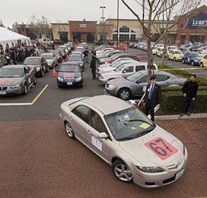 Cars at the Mobile Century command center in Union City head out on their 10-mile driving route on I-880. The drivers, all UC Berkeley students, carried GPS-enabled cell phones that transmitted speed and position information to researchers at the command center, creating a nearly real-time picture of traffic flow. (Paul Kirchner Studios photos) |
Using the GPS data to estimate prevailing speeds and travel times, researchers were able to obtain a picture of real-time traffic conditions. Current traffic monitoring systems primarily rely upon pavement-embedded sensors, roadside radar or cameras. The high cost of installing and maintaining such systems has restricted their coverage to limited stretches of highway.
"For state transportation agencies such as Caltrans, tapping into the vast network of cell phones on the road could one day reduce costs of investing in expensive infrastructure to obtain traffic information," said Randell Iwasaki, Caltrans chief deputy director. "This will greatly expand the coverage of traffic information services so motorists can better plan their trips right on their cell phones."
GPS-based systems can pinpoint a car's location with an accuracy of a few meters and calculate traveling speed to within 3 miles per hour. Enlisting GPS-equipped cell phones into traffic monitoring systems could help provide information on everything from multiple side-street routes in urban areas to hazardous driving conditions or accidents on vast stretches of rural roads, the researchers say.
The Mobile Century traffic project brings together research teams from UC Berkeley and from the Nokia Research Center in Palo Alto that interact through UC Berkeley's California Center for Innovative Transportation (CCIT). These teams are jointly developing the algorithms, software and architecture of this GPS-based traffic monitoring system. Heading the teams are Alexandre Bayen, UC Berkeley assistant professor of systems engineering and of civil and environmental engineering, and Quinn Jacobson, Nokia Research Center research leader.
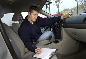 Nokia staffer Dave Sutter does an equipment check to ready a car for deployment in the Mobile Century traffic project. |
The goal of today's experiment was not only to test the efficiency of the traffic data collection and aggregation system, but to also evaluate the trade-offs between traffic estimation accuracy, personal privacy and data collection costs.
"Even though the phones are capable of sending their position and speed every three seconds, an efficient traffic monitoring system should not need to transfer such a large amount of data, which would require enormous bandwidth," said Bayen. "Our challenge is to find the optimum subset of this data for effective traffic monitoring. The quantity and quality of data provided by GPS-equipped cell phones present an unprecedented enhancement to mobility tracking technology and traffic flow reconstruction mechanisms."
Such a powerful system brings up serious questions about cell phone users' privacy, which is why the researchers, with the help of Rutgers University's Winlab, have focused much of the project on mechanisms to protect that privacy.
"Mobile device users control the service. If an individual does not want his or her device to transmit position data, he or she can turn off the GPS feed," said Jacobson. "In addition, data is immediately disassociated from the phone, and is combined with the general stream of traffic data. Only anonymous aggregated data is ever created, transported or stored in this 'privacy-by-design' system. All data is further protected by banking-grade encryption."
"Nokia is very excited at the potential for this system to revolutionize travel planning, carrying on from the Nokia Maps navigation service available today on certain Nokia devices," Jacobson added. "Integration of traffic information with functions such as calendar and online timetables may one day mean the mobile device can act as personal travel planner."
There is currently no projected date for commercial launch of such a system, but when it does become available, its benefits could be huge. In the United States alone, traffic congestion leads to 4.2 billion hours in extra travel time and an extra 2.9 billion gallons of fuel burned, for a total cost of $78 billion, according to a 2007 report from the Texas Transportation Institute. With the number of vehicles on the road increasing rapidly around the world, a cost-effective method of travel planning could help drivers make smarter decisions about which routes to take, the researchers say.
This research project between UC Berkeley and the Nokia Research Center was born of collaborative efforts by UC Berkeley's Center for Information Technology Research in the Interest of Society (CITRIS) and Tekes, a Finnish government funding agency. Both CITRIS and Tekes foster partnerships between universities, research institutes and industry to speed technological innovation to consumers.
The investigators pointed out that their research is ongoing, and that upcoming experiments may focus on thousands of cars - though not necessarily on the road all at once - with participants carrying test phones on their regular commutes.
Today's experiment was supported by a $186,000 grant from Caltrans. Additional support came from the National Science Foundation, Nokia, Tekes, the University of California Transportation Center and the Volvo Center of Excellence for Future Urban Transport at UC Berkeley's Institute of Transportation Studies, which is also home to CCIT.