UC Berkeley Press Release
 From butterflies and lemurs to frogs and geckos, Madagascar is home to thousands of rare species. (Photos [L to R] by Steven J. Phillips, Edward E. Louis Jr., Ronald A. Nussbaum and Miroslav Honzák) |
New Madagascar conservation map protects maximum number of species in biodiversity hot spot
BERKELEY – An international team of researchers has developed a remarkable new roadmap for finding and protecting the best remaining holdouts for thousands of rare species that live only in Madagascar, considered one of the most significant biodiversity hot spots in the world.
In their conservation plan, the researchers, led by conservation biologists at the University of California, Berkeley, not only included lemurs - those large-eyed, tree-hopping primates that have become poster children for conservation - but also species of ants, butterflies, frogs, geckos and plants.
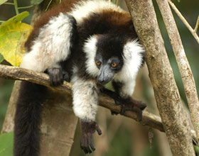
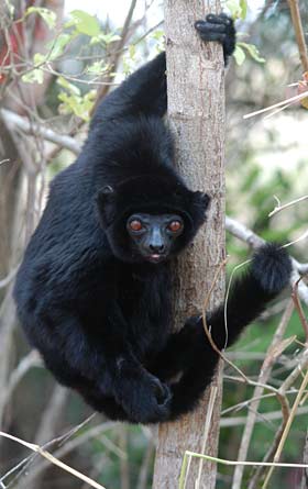
 All species of lemurs are endemic to Madagascar, including the black-and-white ruffed lemur ( Varecia variegata, above) and the Perrier's sifaka (Propithecus perrieri), one of the most endangered of all lemurs. (Photos by Edward E. Louis Jr.)
 |
First, a massive team of researchers collected highly detailed data to learn the exact locations of thousands of animal and plant species across the island. The researchers then used software specially developed for this project, in collaboration with a computer science researcher at AT&T, to estimate the complete range of each species. A separate optimization software, customized for this project by researchers at Finland's Helsinki University, was used next to identify which regions are most vital for saving the greatest number of species. Species that have experienced a proportionally larger loss of habitat due to deforestation were given top priority in the resulting conservation plan because they are at greater risk of extinction.
"Never before have biologists and policy makers had the tools that allow analysis of such a broad range of species, at such fine scale, over this large a geographic area," said Claire Kremen, UC Berkeley assistant professor of conservation biology and the project's co-lead researcher. "Our analysis raises the bar on what's possible in conservation planning, and helps decision makers determine the most important places to protect."
The team's work demonstrates that relying on a single group of species for a conservation plan does not provide adequate protection for other species groups.
"Preserving biodiversity in the midst of tremendous pressures, such as habitat destruction and global warming, is one of humanity's greatest environmental challenges in the 21st century," said Kremen, who worked on this project with New York-based Wildlife Conservation Society, where she is an associate conservationist. "Conservation planning has historically focused on protecting one species or one group of species at a time, but in our race to beat species extinction, that one-taxon approach is not going to be quick enough."
According to some estimates, about half of the world's plant species and three-quarters of vertebrate species are concentrated in biodiversity hot spots that make up only 2.3 percent of Earth's land surface. Madagascar, a developing country off the southeast coast of Africa, is one of the most treasured of these regions of biodiversity.
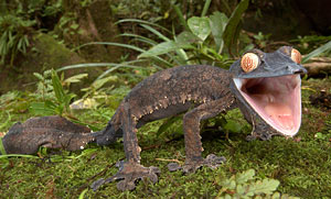
 The Giant leaf-tailed gecko (Uroplatus fimbriatus) is found in eastern Madagascar. If disturbed, it will raise its tail and head, open its mouth and scream. (Photo by Piotr Naskrecki) |
"The diversity of Madagascar is not yell well understood, as a large number of species has been recently described, and new discoveries are made every year," said study co-author David Vieites, a postdoctoral fellow at UC Berkeley's Museum of Vertebrate Zoology and in the Department of Integrative Biology. "For example, since our study began three years ago, some 50 new species of amphibians were discovered. Sadly, because of the high rate of habitat destruction, huge numbers of species will go extinct before scientists have a chance to document them."
Fresh attention was paid to Madagascar when, in 2003, the country's government announced an ambitious goal of tripling its existing protected area network from about 5 million to 15 million acres (20,234-60,700 square kilometers), or about 10 percent of the country's total land surface.
"Madagascar is one of the poorest countries in the world, which makes the government's commitment to biodiversity even more remarkable," said Alison Cameron, co-lead researcher of the project, and post-doctoral researcher at UC Berkeley's Department of Environmental Science, Policy & Management. "Government leaders have developed a very progressive vision for social and economic development, in which the natural landscape is viewed as a valuable resource"
The MacArthur Foundation supported this project with a joint grant to UC Berkeley and the Wildlife Conservation Society, whose staff in Madagascar work with government officials there to incorporate the results of this study into conservation policy. The Wildlife Conservation Society has already established several new protected areas within the country.
Ultimately, a diverse group of 22 researchers from museums, zoos, herbaria, universities, non-governmental organizations and industry contributed to this new analysis. The authors received help from an additional 62 non-authored collaborators who, in turn, were part of much larger research teams that collected the data used in this study.
Another co-author affiliated with UC Berkeley is Brian Fisher, an adjunct professor at the campus's Department of Environmental Science, Policy & Management and chair of entomology at the California Academy of Sciences.
For their analysis, the researchers utilized decades worth of field data painstakingly collected throughout Madagascar by intrepid biologists.
"Simply identifying the species on the island and determining where they are located is very difficult," said Kremen. "The terrain is rough, there are few roads, and we often had to hike 18 miles (30 kilometers) to get to the field site. Once there, we'd live for months in a tent under a tarp, enduring leeches and torrential rainfalls, eating rice and beans, to document the range of animal and plant species in a specific area. This is truly hard-won data."
The rich data source allowed the researchers to map out the habitat of 2,300 species throughout every square kilometer of the island. "We spend years of our lives collecting this data, and people sometimes wonder why we do it," said Kremen, who personally spent the greater part of eight years primarily collecting field data in Madagascar. "It is gratifying to know that the data collected may literally put some species on the map for protection."
Based upon this work, some surprising areas emerged as conservation priorities, including coastal forests and central mountain ranges, which had large concentrations of endemic species. Such regions, the researchers noted, have historically been neglected in favor of large tracts of forest.
"Earlier efforts at conservation planning focused on whether a protected species was included in a designated area, but that region may not include a significant fraction of the species' population for it to remain viable in the long term," said Cameron, who also provides technical advice to the Wildlife Conservation Society and the government of Madagascar. "In contrast, our analysis goes further by maximizing the proportion of every species, so that they achieve maximum conservation, within the target of 15 million acres set by the government. This is a huge shift in approach, made possible through advances in computer technology that allowed us to centralize such a large amount of data and to analyze it all together."
The researchers noted that similarly rich sources of data exist in other parts of the world, and that their method of analysis could be easily transferred to other high priority regions for conservation.
 |
The Adansonia tree, commonly known as the baobab, is known for its ability to endure harsh, dry conditions on its native Madagascar. (Photo by Steven J. Phillips) |

