UC Berkeley and Nokia turn mobile phones into traffic probes with launch of pilot traffic-monitoring software
| 06 November 2008
BERKELEY — Drivers in the San Francisco Bay Area with GPS-enabled mobile phones can soon tap into new technology that promises to transform traffic monitoring. Moments before midnight on Monday, Nov. 10, researchers from the University of California, Berkeley, and Nokia Research Center, Palo Alto will publicly release pilot software that turns cellular devices into mobile traffic probes providing real-time information on traffic flow and travel times.
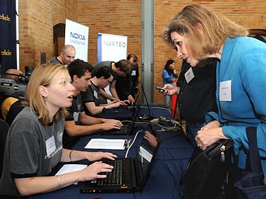
 Lisa Alvarez-Cohen (right), professor of civil and environmental engineering, is among the first early adopters to download the pilot traffic software, with assistance from visiting graduate student Aude Hofleitner. (Peg Skorpinski photos)
 As vehicles pass through the system's virtual trip lines - geographic markers defined by GPS coordinates - the phones will send anonymous speed and location readings to servers. The data will be integrated into traffic models that produce an estimate of traffic flow, then relayed back to the mobile phones and posted online at traffic.berkeley.edu.
The software is being developed as part of the Mobile Millennium project by researchers from UC Berkeley's College of Engineering, Nokia Research Center, Palo Alto and UC Berkeley's California Center for Innovative Transportation. The new system uses digital mapping data from Chicago-based NAVTEQ, recently acquired by Nokia.
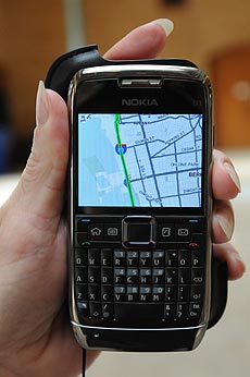
 A GPS-enabled cellphone displays real-time traffic information using software being tested by UC Berkeley and Nokia researchers.
"As we have entered the era of the mobile Internet, cellular devices are providing us with ubiquitous sensing capabilities that will rapidly revolutionize location-based services," said Bayen. "In particular, traffic information systems will be enriched by combining mobile sensor data with static sensor data. The Berkeley research focuses on developing the novel algorithms needed to integrate this data into traffic models and make the information meaningful to the public."
The researchers said the system could eventually spread to include any area with mobile Internet connections, including secondary side streets and rural roads not currently monitored by traffic sensors.
"The proliferation of GPS-enabled devices globally has driven tremendous growth in location-based experiences," said Henry Tirri, senior vice president of Nokia Research Center. "Mobile Millennium, with its unique collaboration of private and public stakeholders, has been designed to demonstrate that everyday people can help address global problems such as traffic congestion. Nokia is proud to be part of this research."
Mobile Millennium is supported by the U.S. Department of Transportation through the federal SafeTrip-21 initiative, which seeks technology solutions to improve safety and reduce congestion on the roadways, as well as by the California Department of Transportation (Caltrans).
"This technology has the potential to provide better quality coverage over more area than has ever been monitored before, allowing motorists to make better traveling decisions," said Randell Iwasaki, Caltrans chief deputy director. "More importantly for state transportation officials, the increased coverage will provide a substantial set of information which will be used to proactively manage the transportation network."
The release of the pilot software comes nine months after researchers put the new technology to its first major road test, dubbed Mobile Century, using Nokia's N95 GPS-enabled mobile devices placed in 100 cars. The pilot software to be publicly released Monday night is partially based upon the prototype version tested during that field experiment.
From the beginning of the project, researchers built privacy safeguards into the system so no data that can be tied to a particular phone will be created, transmitted or stored. This "Privacy by Design" system strips the traffic data from individual device identifiers, uses banking-grade encryption techniques to protect the transmission of data and draws data only from targeted roadways where traffic information is needed.
Nokia's Tirri also emphasized that users ultimately control the service and can turn off the system's ability to transmit traffic data at any time.
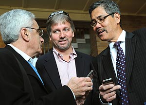
 Adib Kanafani (left), UC Berkeley professor of civil and environmental engineering, observes his new traffic-information software with Rick Warner (center) of Parking Carma and Randell Iwasaki, chief deputy director of Caltrans.
During the first month of the pilot, software downloads will be limited to manage capacity. Additional information about supported GPS-enabled mobile phones will be posted. By April 2009, the researchers expect to reach the estimated pilot system capacity of 10,000 users.
"With this pilot, the San Francisco Bay Area becomes the starting point for the growth of a new cyberinfrastructure system based upon data provided by users," said Bayen. "Eventually, anyone in the country will be able to download the free software to transmit and receive traffic data and participate in the creation of a new traffic information system for their city or community."
"It's been gratifying to have such large public and private entities working together to move this valuable service through its research phases so it can get out to the public," said CCIT Director Thomas West. "The best part about this pilot is that that everyday people can participate, and the more people who use it, the better it will work."
This collaboration between UC Berkeley and the Nokia Research Center was supported by a seed grant from UC Berkeley's Center for Information Technology Research in the Interest of Society (CITRIS).

