|
HOME | SEARCH | ARCHIVE |
|
High-tech maps seen as boon for planners
Geospatial science offers up-and-coming tool for campus facilities managers
![]()
By Diane Ainsworth, Public Affairs
| | 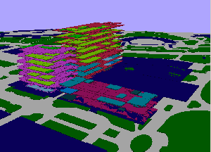 A three-dimensional map of the campus is in development at the Geographic Information Science Center. It uses color codes to provide information such as the location of conference rooms, percentage of occupancy at specific times of day and disabled access. GIS image |
14 November 2001
|
Raphael Bovier, a graduate student in geography from Geneva University, is spending a year at Berkeley’s Geography Information Science Center to build a database of earthquake scenarios for a new online map. When he’s finished, and computer programmers have integrated the information into a 3-D software tool, users such as facilities managers will be able to click on a campus map and see a range of scenarios in the event of earthquakes of varying intensity along the Hayward Fault. Earthquake zones will be defined in different colors; campus buildings will be color-coded to indicate the severity of damage likely to occur in quakes of different magnitudes. Constructing the map requires the development of a computer system capable of acquiring, storing, manipulating and displaying “geographically-referenced information” — that is, data identified by location, explains Katherine Mortimer, assistant director for administrative applications at the Geographic Information Science Center. The technology — called a Geographic Information System (GIS) — is already being applied by government and private organizations to map environmental resources, anticipate emergency response routes and plan public transportation. Uses related to safety Several years ago, Professor John Radke, director of the center and an associate professor in the College of Environmental Design, used the technology to identify the most fire-prone areas in the East Bay hills surrounding campus. Since its founding in 1998, the center — a leader in geographic information science and its applications — has constructed several simple, interactive maps with the help of other campus departments. Capital Projects, for instance, developed a map showing the land contours of the central campus, including faults that crisscross the geography. That map serves as the basis for Bovier’s current work and for ongoing disaster preparedness efforts. The center is augmenting those efforts by gathering information on campus building occupancy. Eventually the database — when integrated into the earthquake preparedness map — will give campus building administrators a 3-D picture of classroom occupancy at any time of the day. Universities adopt geospatial mapping The University of Oregon uses a spatial map for maintenance, planning and analysis of its grounds, Mortimer said. Harvard’s Web maps allow viewers to activate and deactivate various layers of information. Berkeley and Rice University have online maps for disabled access. And Stanford University’s interactive GIS map, built by the Berkeley center, allows Internet users to view maps of campus thoroughfares, parking lots and emergency assembly areas, as well as local faculty housing and other information of general interest to the campus community. So far, the center’s maps of the Berkeley campus have focused on bike paths, fire hazard studies and physical planning. In one class project, students used time- and- location-specific data to identify an appropriate location for a temporary, or “surge” laboratory facility. In the classroom, students have begun using these Web maps to learn about geography, the environment and space exploration. That project is developing real-time monitoring information, maps and imagery to monitor the ecology of the bay and nearby coastal areas. Another effort is producing maps to help assess development capacity in Merced, where the University of California prepares to open the doors of a new campus in 2005.
“This kind of spatial map serves a variety of purposes, many of which are related to human safety,” Mortimer said. “It would be an invaluable tool for improving security around campus, as well as for refining our earthquake preparedness and fire prevention programs.”
“When you add the spatial component to data, like taking measurements of the location and extent of vegetation types and conditions, you are able to build comprehensive visual models of the data,” Radke said. “Assembling geographic data this way and being able to manipulate it to understand complex situations, like fire hazards or possible earthquake hazards, is crucial to improved disaster modeling.”
Geographic information system mapping is a relatively new science. Several universities — the first to go public with more elaborate GIS Web maps — have crafted a variety of them for the public and for more effective management of their own facilities.
Other applications of the technology are becoming more apparent in the wireless world of satellite communications. GIS mapping can be used to create a comprehensive picture of a complex situation. In an era of heightened security after Sept. 11, for instance, it could provide campus administrators with instantaneous information about building occupancy, pedestrian and vehicular traffic flow and structural damage in an emergency.
Several ongoing research projects between Berkeley and the outlying community, such as the San Francisco Bay Demonstration GIS Project, are also helping advance the technology, Mortimer said.
Home | Search | Archive | About | Contact | More News
Copyright 2000, The Regents of the University of California.
Produced and maintained by the Office of Public Affairs at UC Berkeley.
Comments? E-mail berkeleyan@pa.urel.berkeley.edu.