Berkeleyan
Obituary
Robert N. Colwell
![]()
04 May 2005
 Robert Colwell |
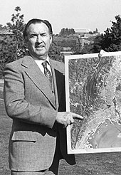
Over the course of more than half a century, Colwell developed a reputation as one of the world's most respected leaders in remote sensing, a field he stewarded from the interpretation of aerial photographs to the advanced acquisition and analysis of many types of geospatial data. His career included nearly 40 years of teaching and research at Berkeley, a distinguished record of military service, and prominent roles both in private industry and as a consultant for many U.S. and international agencies.
A native of Star, Idaho, Colwell entered Berkeley as a 16-year-old freshman; he earned a B.S. in forestry in 1938 and a Ph.D. in plant physiology (from UC Davis) in 1942. Shortly thereafter he was commissioned in the U.S. Naval Reserve, where he was an air-combat intelligence officer for the invasion and capture of Guadalcanal; he then served as chief instructor of the Navy's Photo Intelligence School in Washington, D.C., and, finally, chief of photo intelligence for the planning and execution of the Okinawa Campaign. At the end of the war, Colwell was placed in charge of the Navy's training programs in photo interpretation and photogrammetry.
While he continued in the Naval Reserve after the war, in 1947 Colwell was appointed to the faculty of the School of Forestry, where his focus on photographic interpretation later evolved into a program in remote sensing. His accomplishments included development of aerial photography methods to identify tropical vegetation, determine water depth, and measure the prevalence of diseases in agricultural crops.
From the 1960s on, Colwell pioneered new methods of satellite photography and reconnaissance. He intuitively grasped that new fluorescent and radiographic techniques would forever change human ability to observe and map the Earth.
"Just as our musical appreciation is increased greatly when more than one or two octaves are exploited," Colwell wrote in a 1961 American Scientist article, "so also is our appreciation of the physical universe, through multiband spectral reconnaissance, which already can exploit more than 40 'octaves.'"
Colwell was a voracious writer, authoring more than 400 scientific and professional articles and editing the two definitive references in his field: The Manual of Photographic Interpretation(1960) and The Manual of Remote Sensing, 2nd Edition (1983).
Colwell was a catalyst for the development of remote-sensing techniques during his service as associate director of Berkeley's Space Sciences Laboratory from 1969 to 1983. He went on to play an instrumental role in the launch of LANDSAT 1, which almost immediately revolutionized the fields of cartography, forestry, geology, and land use.
Despite his other obligations, Colwell continued to serve in the Naval Reserve, working in photographic intelligence during the Korean and Vietnam wars and on other special assignments over the years. In 1974, he was promoted to rear admiral and became the first director of the Naval Reserve Intelligence Program, a position he held until 1977.
In the private sector, Colwell's research in multi-spectral analysis provided a key asset in the early days of Earth Satellite Corporation, where he had a lead role in mapping for the first time 6 million square acres of the Amazon Basin.
Colwell retired from the university in 1983 but continued his work on the board of directors of EarthSat Corporation and as a private consultant. In his private life, Colwell was an active member of the Presbyterian Church and an avid trout fisherman.
Colwell married Betty Louise Larson in April 1942. Their marriage lasted 57 years, until Betty's death in 2000. He is survived by their four children - Arthur Colwell of Lakeport, John Colwell of Ann Arbor, Mich., Nancy Colwell Coronado of Benicia, and Robert Colwell, Jr., of Vienna, Va. - and seven grandchildren.
Donations in Colwell's memory may be made to the Deacon Fund or the Building Fund at Walnut Creek Presbyterian Church, 1801 Lacassie Ave., Walnut Creek, CA 94596.
- Cyril Manning

