

Berkeleyan
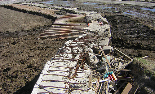 This concrete floodwall and its steel-pile anchors, originally sunk into the levee top along New Orleans' Industrial Canal, was thrown on its back by the force of Hurricane Katrina's storm surge, allowing water to flood the city's Lower Ninth Ward. Berkeley engineers examined damaged and destroyed levees and floodwalls during a weeklong visit to New Orleans in October, and will soon present formal recommendations based on their findings.(Rune Storesund photos) |
Big hurt in the Big Easy
A team of Berkeley engineers pokes through Katrina's rubble in search of clues that could help prevent the flooding next time
![]()
| 20 October 2005
It's hard to pull your eyes away from the mud-encrusted homes of New Orleans' Ninth Ward. Splintered or partially collapsed houses stretch as far as the eye can see, amid a shallow sea of dark-gray mud already dried and cracked into jigsaw-puzzle pieces. Dirty, rusting cars line the streets at odd angles; overhead wires dangle threateningly into the street; awnings creak in the breeze. An eerie silence emanates from the deserted streets, disturbed only by the occasional burr of a cicada or a bird chirping from the ravaged trees.
And scattered everywhere is the personal flotsam of people's lives. It's embarrassing to look at the jumbled mattresses, the clothing, the portraits of children in graduation robes lying in the dried mud, and the now-homeless teddy bears and dolls.
But we are here to look at the levees, not the damage the levee breaks caused. Ray Seed, a Berkeley professor of geotechnical engineering, assembled a troop of engineers that touched down in New Orleans on Oct. 2 - a month after Hurricane Katrina spun into the area - to investigate the levee failures that devastated the Ninth Ward and many other neighborhoods of the city.
"The evidence is disappearing as we speak," Seed said after a week on the ground. "Some things we saw early in the week are already buried as they rebuild the levees."
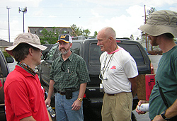 Ray Seed (in Cal cap) and Bob Bea (hatless) prepare to drive the New Orleans levees with colleagues from ASCE and the Army Corps of Engineers. |
They reached the scene none too soon. The New Orleans District of the Army Corps was rapidly repairing the levee and floodwall breaks to protect against storms that could strike during the remainder of the hurricane season. In the short time Seed's team was in the city, bulldozers completed a neat flattop of gravel on the patch at the Industrial Canal breach that flooded the Ninth Ward. Everything in the breach - sand bags, debris, and clues to why the levees failed - was being buried under dirt, stone, and gravel.
| Among the Berkeley team's recommended alternatives for New Orleans' long-term flood-defense system: . Re-establish the wetlands and barrier islands that lie outside New Orleans. . The canals that run through the city could be replaced by underground concrete storm-drain culverts or tunnels, eliminating miles of levee and possible weak links in the levee system. . Provide design details that will minimize scour effects when concrete floodwalls are overtopped. Splash guards, piles of large rip-rap, or even paving paths for joggers and cyclists along the tops of the levees could be useful. Alternatively, place armor at the front and back faces of floodwalls to prevent erosion. . Build all floodwalls, floodgates, and stand-alone levees to the same height, and pay special attention to how the adjoining pieces actually join together, to lessen the chance of failure where different materials and construction techniques meet. |
The once-vertical sheet-piles beneath Seed's boots were identical to those that form the foundation for all the floodwalls topping the miles of earthen levees that provide New Orleans with additional protection from high tides and storms. They are essentially interlocking steel slats pounded along the entire length of the levee embankments, then encased in concrete. These steel-and-concrete floodwalls have been a crucial part of the vulnerable city's levee system since Hurricane Betsy made landfall in 1965, doing substantial damage. The system was subsequently strengthened to withstand a Category 3 hurricane, judged to be a once-in-every-200-years event.
Katrina, of course, was the dealbreaker. When it struck New Orleans, it was a Category 4 storm lumbering northward across nearby Lake Pontchartrain. Though it didn't strike the city dead-on, Katrina's winds piled Pontchartrain water along the hurricane's margins in a destructive surge that tossed yachts into one another like bowling pins.
Though most of the Pontchartrain levees survived, the weak links were two of the canals that drain the city (the 17th Street and London Avenue canals) and the Industrial Canal that links the Mississippi with the lake and the Intracoastal Waterway. Pumps constantly pull water from city areas below sea level and dump it into the canals, which drain into the lake. The Katrina surges funneled water up these canals and pushed the floodwalls aside in three areas. Once they were breached, the water poured in to submerge nearly the entire city.
Observations made by the Berkeley team and the ASCE engineers led them to conclude that the Industrial Canal levee that failed in the early hours of Aug. 29 was simply overwhelmed and overtopped by walls of water from Lake Pontchartrain. The water driven over the floodwall by Katrina's winds scoured the dirt and gravel out from behind the wall, undermining it and allowing the force of the water to throw it on its back. The floodwaters pouring in from the Industrial Canal, coupled with a 24-foot wall of water surging across the bayous from the east, pinched the primarily African American Lower Ninth Ward, the poorest region of the city.
"It's as if God targeted the Ninth Ward," Seed said.
Levees and banana peels
To put their findings out quickly to the public, Seed joined colleague Peter Nicholson, an associate professor of geotechnical engineering at the University of Hawaii and head of the ASCE geotechnical team, at an open-air press conference on Friday, Oct. 7, at the levee break along the 17th Street Canal. With Paul Mlakar, a senior research scientist at the Army Corps' Engineering Research and Development Center in Vicksburg, Miss., the Berkeley team and the ASCE team presented a consensus view of the New Orleans levee failures.
The Corps initially thought that all the failed levees had been overtopped by the wall of water pushed ahead of the hurricane. Seed and Nicholson announced, however, that their evidence pointed to the failure of two levees - alongside the 17th Street Canal at Robert E. Lee Blvd. and the London Avenue Canal at Mirabeau Bridge - without overtopping. The high-water mark on the 17th Street Canal was 28 inches below the top of the floodwall, and there was no evidence of scouring from overtopping water behind sections of the concrete levee floodwalls adjacent to the breach. A heave pile of dirt in front of the broken floodwall suggested instead that the pilings had scraped the earth as the force of the water pushed the floodwall forward.
The team ascribed these two breaches to soil failure at the base of the levees. Acknowledging that levees are, by definition, built on poor, marshy soils, Bea noted that weak soils associated with a peat layer at the base of the levee likely allowed the levee and wall at the 17th Street Canal to slide laterally by about 35 feet, "like stepping on a banana peel." A similar peat layer seemed to be involved in the London Avenue Canal breach.
In one-on-one interviews with reporters from The New York Times, the Washington Post, The Wall Street Journal, the New Orleans Times-Picayune, National Public Radio, and The NewsHour With Jim Lehrer, Seed, Bea, and Nicholson laid out their observations and cautioned that the poor soil still underlying the patched levee needs to be taken account of as the levee is repaired.
Both the Berkeley and ASCE teams plan more data collection, testing, and analysis before they can determine precisely why each levee performed as it did. Seed, Bea, Storesund, and team members Jonathan Bray and Juan Pestana (both of whom are geotechnical-engineering professors at Berkeley) hope to issue an interim report on their findings within two to three weeks, with a final report to the Corps and the NSF in six months. The ASCE geotechnical team led by Nicholson will prepare a separate report.
"It's important to get our report out as soon as possible, while the Corps is repairing the levees and before it makes final decisions on how to rebuild the levee system," Seed said. "This comprehensive understanding will form the basis for the recommendations that will help provide future protection for the residents of New Orleans and elsewhere in the nation."
Building to the wrong standards
Earlier in the week, Bea, Storesund, and a dozen ASCE and Corps engineers had piled into three SUVs for a tour of the heavily hit levee bordering the Mississippi River Gulf Outlet. Driving along the crest of the levee, it was obvious to even the untrained eye that Katrina had battered and severely damaged the defenses that protect eastern New Orleans. As Katrina swept over the lake, its winds sent a 24-foot wall of water across the channel, over the levees, and into the bayous beyond. That surge continued over the marshland to inundate Chalmette and the Ninth Ward.
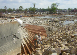 ASCE geotechnical-team members inspect a portion of the floodwall along the Industrial Canal that was overtopped and flattened by Katrina's storm surge. The force of the storm shattered much of the concrete wall that topped the steel sheet-piles. |
Elsewhere, a beached oil barge nearly blocked the levee road, tipping slightly, while a floodwall, chipped but intact, stood solidly against the combined weight of three wayward barges.
A Corps launch took the team of engineers for a ride down MRGO, providing a storm's-eye view of a levee that had been overtopped, worn down, and breached, but that still stood its ground. Sheet-piles, however, fared badly in many places, evidently wrenched in all directions until they pulled apart.
Bea expressed doubt that these levees could withstand a Category 3 storm, let alone a Category 4 like Katrina. An expert in organizational behavior, he faulted the Corps for building up the levees to a single, inadequate standard and not confronting the weaknesses and vulnerabilities of the levee flood-defense system.
"The Corps of Engineers built to a set of standards, but they were the wrong standards," he said, noting that even though 1965's Hurricane Betsy was a Category 4 hurricane, the Corps continued to strengthen levees to withstand only a Category 3 storm. Bea is also aware, however, that the Corps from its inception was mandated to focus on specific projects, not the whole picture. With declining funds and a strictly defined mission, the failure of the flood-control system was almost inevitable.
"We tied their hands, and we got what we paid for," Bea said.
The Berkeley and ASCE teams concurred that jurisdictional issues may have created weak links in the levee system. Ports, railroads, parishes, and the Corps all have different construction techniques and maintenance standards, and where levees and walls cross jurisdictions, failures are more likely. Bea pointed to a railroad floodgate at the lakeside port that had been damaged by a train and not yet repaired when the hurricane struck. The team is still investigating whether the gap was adequately sandbagged to close the resulting gap, as there is evidence that this was a point of entry for floodwaters along that levee section.
"It would be like leaving the drain open in a bathtub," another team member said. "It's a recipe for potential disaster to have 70 miles of levee, and then have so many different people in charge of different pieces."
Said Bea, emphatically: "This problem is much broader than the Corps of Engineers or any other individual group. At every interface we encountered in our investigation - whether between soil and concrete or people and organizations - there has been a breakdown. We must find a way to work with the organizations so the interface itself is not the point of weakness."
Bea's earnestness is informed by his personal history. When Hurricane Betsy struck in 1965, he was working for the Shell Oil Company and living in the Gentilly-Pines Village area around the Industrial Canal. During his week on the ground, he visited the neighborhood he and his family had occupied before they were flooded out. He choked up as he described how he'd seen the current resident, living in a house built on the same concrete slab as Bea's old home, hauling ruined mattresses into the street, just as Bea did 40 years ago.
"Some people have enough resources to come back," he said. "But there are others - whose lives were on the brink of chaos before the hurricane - who will need a lot of support, psychological as well as financial, to return.
"It will be a long, difficult process, and some will never come back."